App Idea - Ghetto Minder ( Alkiphron ? )

i think @Alkiphron said he developed apps for a living ? i may be mistaken. think i will give him a day to express interest then i’m posting this on NOSTR.

basically i was on my 2nd tour of Boston and set GPS to “Cambridge” which was LOADED with chicks - because there were universities everywhere - Harvard, MIT, some music school, other schools etc … for like 10 or 20 blocks one in five people on the street was a college girl or so - very nice.

but then i accidentally drove into a block with like 20 or 30 homeless people on a single block, most centered around a single intersection … niggers, cripples - all the good stuff.

then i hit traffic on highway while low fuel light was on and google was suggesting faster route if i pulled off the highway so i figured i will get off and get some gas … bad mistake ! pulled off and ended up in a ghetto … half of the stalls at the gas station didn’t work and there was a line of niggers for the other half and when i ( very careful not to seem to jump the line ) finally got to the pump there was a sign saying credit cards don’t work ( ice creem masheen aint work ) and that i have to pay cash inside … i was like no way and just got out of there …

i do use this map:

https://bestneighborhood.org/race-in-massachusetts/

which is a great map for census data but i feel what i see on the ground is substantially different than what that map shows. the bestneighborhood map is not wrong, it simply doesn’t show things the way you see them when you’re actually on the ground.

my idea for the app is - users report niggers, homeless and hot chicks by clicking a single button and it is automatically mapped using GPS.

i believe WAZE ( which i don’t use ) or some other app has functionality to map cops with speed traps on the highway or something like that in real time … well this would be like that except it wouldn’t even need to be in real time …

those homeless are always going to be on that intersection … people on their block were making some kind of gesture with their head that i never seen anywhere outside that one block … it was either a threat or show of contempt or something like that but it was literally unique to that couple blocks around that intersection …

i mean i was looking at everybody because i was specifically on a mission to study the demographics of Boston - the college girls assumed i was interested in them ( because their life is that of being lusted over ) while the street trash assumed i was threatening them i guess ( because their life that of fighting other subhumans on the street ) …

but what is important to us is how while on the ground you could see a very sharp change in people and the way they acted in just a few blocks, which in a car is only 2 or 3 minutes. the bestneighborhood map simply doesn’t show this because it looks at large areas ( rather than single blocks ) and then documents who is registered at that address rather than who is actually there …

so for example according to bestneighborhood maps i was not in Boston at all, because i wasn’t registered at either MA or NH address, and yet i was very much there.

and needless to say the homeless were also not there according to bestneighborhood maps because they aren’t registered at any address …

when i went to Uni in NYC i lived at home so i actually have no idea if those college girls are registered for census purposes to live in some dorm or back at home in whatever state they’re from …

either way you get the idea - where somebody’s registered address is versus where they actually are isn’t always the same.

a NYC example would be that most people on manhattan street on any given day are NOT from manhattan … they commute there for work … so there may be a white guy living in Manhattan whom you never see because he always works … or you may have some black homeless person who doesn’t live anywhere but is always in your face …

the discrepancy between bestneighborhood map and reality is part of the reason i must tour these areas in person ( other reason is i need to check things like potholes etc. ) …

but an app that simply puts a color dot for every “encounter” on the map would solve this …

here is an example of NYC demographic dot map

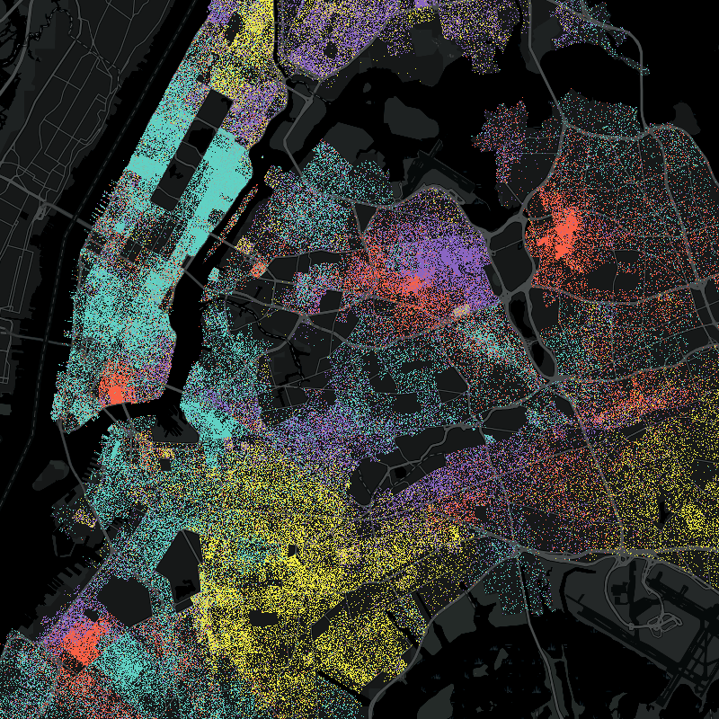
usually such maps are on white background

a user could be given a choice of light or dark mode i suppose …

so basically an app that uses GPS and user input to automatically generate a dot map of reality as seen on the ground ( not based on official address registrations )

you would also be able to make your own custom maps. for example you want a map that only shows niggers, wet backs and homeless. you check those boxes and a map is generated for you.

or you only want to see a map of hot chick sightings - you can have that too.

now i don’t know why anybody would report hot chicks instead of trying to hog them all for himself but those kinds of details can be worked out in the future. there may be some way to incentivize users and / or use AI to check if a user is being truthful etc.

the real question is - would this even be legal ? like is it legal to to create a map of sexy young girls ?

pretty sure you would get in trouble if you tried to create a map of children for pedophiles but college girls should be fair play ?

actually the image i used above is a perfect example of the problem:

according to this image there are NO people in either the Central Park in Manhattan nor JFK or LaGuardia airports … simply because nobody is registered to live in a park or airport …

yet obviously both of those places are not only packed, but it’s where you actually meet people ! you don’t meet people in their homes ! ! !

our user-generated map would be almost the exact opposite of the map above. it would be on absolute fire in the central park and airports and quite dim in residential areas where nobody goes except people who live there and they aren’t going to report themselves …

i will give you a few more examples.

one time i went to a park and everybody in that park was a wetback even though the area itself was white. this is because if there are two ethnicities in an area and two parks they will eventually figure out who goes to which park - but only locals to that area will know this.

imagine taking a girl out on a date to a park and and ending up being surrounded by a bunch of illegals from mexico cat calling her. it would be the last time you see her either because you did nothing and showed yourself a pussy or because you did something and got killed. even if you were able to handle them like a pro your judgement would still be in question for taking her there in the first place.

again, there is currently NO map that will show you demographics in a park.

if the app launched today it would have no competition.

yes you can go on Yelp and read park reviews but in a park where 100% of visitors are mexicans the reviews will be written by mexicans themselves who will say it is a great park.

what i uses to do in cases like this is instead of READING the reviews look at the profile images of the people who WROTE the reviews.

if every picture is of somebody black then it doesn’t matter what their review actually says - it is not some place you want to go.

but think of how inefficient that is - a person needs to write an entire review and post their picture trying their best to look sexy or successful when really all you needed was a color dot, and anybody who saw them in that park could have posted that dot for them.

also when it comes to yelp or google reviews of parks people aren’t obligated to use their photo for an avatar. for example i do NOT use my photo in my yelp reviews.

something else we could do is instead of asking people to choose a description of who they saw simply let them click on a picture of a person that looks most like who they saw

for example


or

then when you click on some location, such as a park, it shows you a collage like this:


of people in that area as perceived by others. you won’t actually take pictures of anybody but rather just represent them with avatars of your choosing.

our brains are wired in such a way that we will be able to instantly interpret that data and in a split second know if that’s a park we want to go to or not.

like imagine if 3/4 of the people in that collage were george floyd - only a total retard wouldn’t slam on the brakes and pop a u-turn.

Yes, I do develop apps for a living. The concern I have is that if I made this as an Android app it would be banned from the Play Store as soon as they knew what it was. Same for Apple. However, there are ways around this because Google (or Apple) no longer has an absolute monopoly on maps, but the ban is a big deal because then you have to sideload apps, as you have to for example with Gab – no problem for internet shitpoasters but normies aren’t going to figure that out. And to be useful we’d want many to be using it. So it seems you’d want to go with a web app as Google or Apple doesn’t have absolute control over those, but your hosting still might get targeted if the wrong people found out. I don’t think anything here is technically illegal, but would definitely become a target of cancel culture.

I will read the rest of the thread now, but I just wanted to voice the obvious concerns. Might as well post it to NOSTR as well, as some devs on there might be able to get to it faster than I would. I have also been traveling recently and had limited time.

1 Like

One thing that might make it less obvious is using proxies or euphemisms, for example “college crowd” or “diverse neighborhood” or “encampment” as those are all proxies for what we are looking for. But it would also have to be clear enough for normies to get the idea about what it is they are posting.

1 Like

i literally just thought of it and posted 5 minutes later.

i should flesh out the idea a bit more and then post on NOSTR.

The other thing that comes to mind is that in the last ~5 years we have seen the rise of decentralized applications (dApps) using the blockchain and similar. These would be more resilient to censorship by bad actors. I have no experience with these though, as I have mostly worked in more conventional web and mobile apps in my career. But I also have been meaning to learn, especially since I have to refresh my skills periodically anyway to stay current. Some of the devs on NOSTR would know about this.

yeah that’s a though i had as well - it could be implemented using NOSTR protocol.

the protocol is flexible - it isn’t just for Twitter alternatives.

it seems to just store “events” on “relays” but the “event” can be anything. it can be a tweet or it can be somebody marking a Nig on a map.

frankly the NOSTR protocol could be brilliant in the degree of flexibility it allows …

it really isn’t a protocol at all - but a framework for collaboration

not sure there has ever been anything like it … it doesn’t seem to define much at all and yet somehow it works and is evolving all the time while continuing to work …

maybe Bitcoin was like that ? i don’t know how it works in enough detail to to say either way. i was impressed by how Ethereum was able to switch from proof of work to proof of stake - that seems crazy to me - it seems like switching cars while on highway speed or something.

but NOSTR is definitely like that.

i guess maybe it also reminds me of internet protocol itself - only instead of packets it has events. then out of those blocks you can build anything.

i guess the key is to not over-define things. define just enough that things can work and leave everything else open to evolution.

i probably sounded like a retard there because i don’t actually know how any of these things work just speculating …

came across this meme on NOSTR today


it really do be like this.

you walk into some space and find a particular demographic there that you wouldn’t be able to guess would be there from either people outside or a demographics map …

Ghetto Minder app solves this …

actually i came up with alternative name - FaceMap

but even that may not be good enough, because i realized this app should be used for more than people. it can be used to map other notable things like fancy cars - for example if you see a ferrari or something.

when i was in Hollywood i saw more supercars in one hour than i have in 20 years of living in NYC for example.

or you could map exotic birds or anything at all … just anything that catches your eye, both positive and negative.

homeless people, junkies, prostitutes, cops, potholes - whatever !

the point is to collect as much data as possible ( like Google does ) then you can process it and monetize it eventually once you figure out how …

you could map ratings for things like noise, stench, street lighting, overall pleasant-ness of the area etc.

the key would be to find a way to reward people for submitting ratings and making sure they aren’t making them up randomly just to get rewards.